
Deep Collaboration for the Great Bear Sea
The Marine Plan Partnership has fundamentally changed how sustainable marine planning is done on the North Pacific Coast.
British Columbia Reconciliation Award
In April 2021, the Marine Plan Partnership was honoured with a British Columbia Reconciliation Award in recognition of exceptional leadership, integrity, respect, and commitment to furthering Reconciliation with Indigenous peoples in the province of B.C. Read about the award.
What is MaPP
The Marine Plan Partnership (MaPP) is a unique partnership between 17 Indigenous First Nations governments and the British Columbia government that recently worked together to develop a ground-breaking "blueprint" for ocean use and sustainable economic development.
Building on the historic Great Bear Rainforest Agreement, which set out to advance protection and human well-being across 19 million acres (76,890 km2), Nature United is leveraging our global expertise to advance one of the most comprehensive marine management plans in the world.
Infographic
-
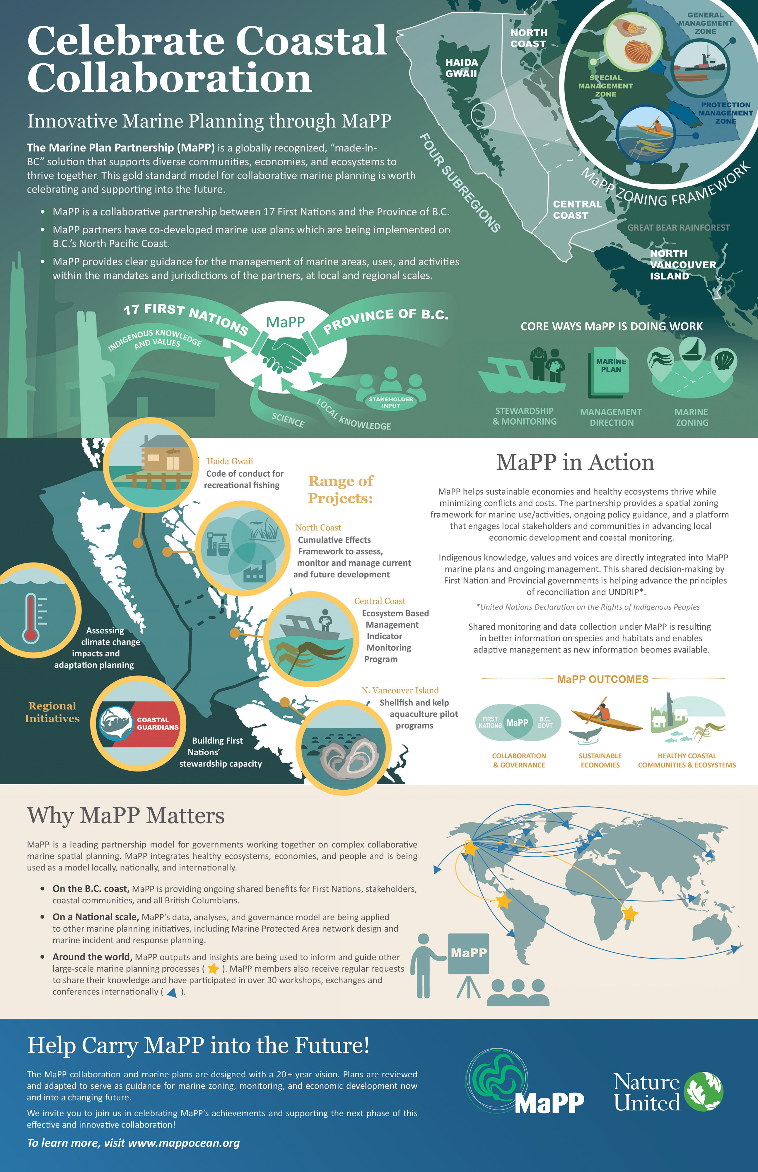 Celebrate Coastal Collaboration
Explore what makes MaPP such a successful collaboration for ocean health.
Download
MaPP has dramatically shifted resource governance in the marine environment of the North Coast. The MaPP plans are strengthening First Nations’ leadership and integrating indigenous values in day-to-day decision making for sustainable and culturally-relevant economic developments. After four years, the benefits are already substantial—boosting the capacity of the Indigenous Guardian Watchmen, expanding the Provincial marine resources team, improving tenure and permit application decisions and ensuring data are available to monitor the effectiveness of the new marine zoning plan.
Outcomes
The overarching goal of MaPP is a resilient and productive marine environment that protects biodiversity and supports sustainable marine economies. By supporting the implementation of MaPP, we are advancing the following objectives:
- Strengthen governance relationships across Provincial and Indigenous governments, and marine and coastal stakeholders, that are key for effective and collaborative ecosystem-based management.
- Develop and implement marine spatial plans to provide guidance for decision-making related to resource use, conservation and economic development.
- Enhance stewardship of ecological and cultural values with comprehensive monitoring and enforcement.
- Foster a new ecosystem-based marine economy that improves community and human well-being.
To date, MaPP has achieved several outcomes that contribute to Enhancing Ecosystem Integrity, Sustainable Economic Development, and Improving Governance and Resource Management.
MaPP is the first ocean management plan jointly led by Indigenous peoples and a state government.

Enhancing Ecosystem Integrity
Increasing protection of marine biodiversity: 16,000 km2 in new “protection management zones” throughout the region. Many of these areas are now prospective sites for federally legislated Marine Protected Areas.
Expanding monitoring and surveillance: Guardian Watchmen programs have expanded their capacity across the MaPP region. A regional kelp monitoring program was recently launched. Nations are actively monitoring critical fish/shellfish populations, marine habitats and a suite of ecosystem and social indicators. An Aquatic Invasive Species Management Plan was created for Haida Gwaii.
First Nations engagement in fisheries management: Dungeness crab monitoring by Central Coast Nations showed evidence of a population decline and resulted in area closures to assist recovery. These Nations are now actively involved in crab management discussions, and Dungeness is 1 of 27 indicators being monitored in all regions.
Addressing climate change impacts: MaPP completed a regional assessment of current and projected climate change impacts to inform proactive planning and adaptation.

SUSTAINABLE ECONOMIC DEVELOPMENT
Guiding project proposals and referrals: The MaPP sub-regional marine plans were referenced in provincial files for 68% of the new tenure authorizations and 49% of the tenure replacements in 2018.
Catalyzing marine economic development projects: MaPP plans include strategies to expand shellfish aquaculture. Multiple commercial shellfish aquaculture assessments highlight feasibility and longer-term business opportunities.
Enhancing recreation and tourism opportunities: The MaPP Partners collaborated with the B.C. Marine Trails Network Society on design criteria and visitor guidelines for a marine trail in the Discovery Islands.

Improved Governance and Management
Transforming relationships and “business as usual”: MaPP is providing the foundation for a new model of collaborative ocean management between governments, Indigenous communities and industry.
Increasing information and data for decisions: more than 250 spatial data layers viewable on a MaPP Marine Planning Portal for species, habitats, marine uses, ecological analyses and more.
Enabling other complex multi-government initiatives: MaPP relationships are critical for a new tri-lateral, large-scale initiative initiated by the Federal government for MPA Network planning and emergency plans to respond to spills and vessel accidents.
Enabling more rapid, adaptive, and place-based responses: Completed a regional strategy for marine incident response planning, including notifications, logistical needs, protection sites and geographic response strategies.
Global Significance of MaPP
Indigenous Co-Led Partnership
MaPP represents the first co-led marine planning effort by Indigenous peoples in the world. The signing of MaPP was a landmark moment in British Columbia and has provided inspiration to other marine plans involving indigenous peoples including New Zealand and Indonesia. The co-led planning resulted in stronger governance relationships and high agreement on priority issues and strategies to improve management of the Great Bear Sea for generations to come.

Large-Scale, Science-based Conservation
Using more than 250 data layers across 102,000 square kilometers, scientific analyses supported discussions and finding agreement for high priority areas for biodiversity conservation. All told, 241 Protection Management Zones were identified using systematic conservation planning methodology and “best practice” principles for MPA networks including replication, connectivity, and representation for the full suite of marine species and habitats. The protection zones cover 16% of the study area and are a significant contribution to the development of a network of MPAs which is helping Canada reach its target to protect 10% of the marine environment by 2020.

Cross-Cutting Issues
MaPP is a globally significant example of a plan that crosses multiple sectors, issues and challenges. The marine plans and action framework address incorporate a diverse range of views related to marine protected areas and long-term conservation. Special Management Zones provide siting for existing and future sustainable development such as aquaculture, renewable energy and culturally significant areas. The plans also incorporate cross-cutting issues like climate change adaptation for sea level rise, ocean acidification and storm frequency.
Global Model
MaPP is held up as using, and in several cases exceeding, "best practices" for marine spatial planning – strong governance framework, evidence-based decision-making, robust stakeholder engagement, multiple knowledge and data sources, guiding principles from ecosystem-based management and an implementation plan.
The lessons learned from MaPP are shared around the world to advance the evolution of marine spatial planning including other geographies were our global affiliate, TNC, works. Guidance for process steps, decision-making, stakeholder engagement, financing, EBM indicators, and implementation are among those shared to other geographies.

Our Role
At the invitation of First Nation partners as well as the federal and provincial governments, Nature United is playing a key role in supporting MaPP. We have provided core funding that enabled the MaPP stewardship and planning staff to implement on-the-ground work in the subregions, and we are helping MaPP develop sustainable financing so these activities continue into the future. Nature United also provides critical support to the Indigenous Guardian Watchmen Program — the on-the-water eyes and ears monitoring and stewarding the MaPP region. And, we regularly bring our science and fisheries expertise to the table. Examples of this work in action include:
- Helping to develop and operationalize a collaborative regional kelp monitoring program;
- Building the business development and management capacity of First Nations-owned and operated fisheries in the region;
- Using our global reach to bring the “MaPP model” into other ocean regions doing marine spatial planning.
Resources
The MaPP Plans will continue to be implemented and we look forward to reporting on the project developments and new initiatives driven by this unique triple-bottom-line vision for healthy oceans and thriving coastal communities.
MaPP governance partners, data, and “protection management zones” are critical components in the development of a new Network of Marine Protected Areas (MPAs) in the Great Bear Sea. Nature United is working to support the MPA technical team to ensure the best available science and engagement practices are involved in this effort to advance marine protection over more than 25 million acres of ocean.
Support This Work
Get in touch with us to learn more about our work in Great Bear Sea, or make a secure online donation.
More Stories

10 Years of Collaborative Marine Planning
The Marine Plan Partnership has fundamentally changed how sustainable marine planning is done on the North Pacific Coast.

Reimagining Conservation in Great Bear
The Great Bear Rainforest is an important carbon storehouse and biodiversity hotspot.

Indigenous Guardians
Indigenous Guardians are the “eyes and ears” of their territories – they are men and women who are using Indigenous knowledge and practices, blended with western science to monitor and steward their traditional lands and waters across Canada. Nature United supports these important programs with technical tools, networking, research, and more.